Senin, 24 Januari 2011
Flyers-Hawks meet for first time since Final
The Philadelphia Flyers come to Chicago on Sunday for their first meeting with the ..."
Because the world is not flat..
A rather geeky first post for the New Year, but that’s no bad thing.
So the launch of an interesting if niche extension to the Google Maps javascript api, you can read Thor’s blog post here, but as of today you can now use a new library of functions as an addition to the javascript api to carry out spherical geometry calculations.
The world is no longer flat !
This has for a long time been a blind-spot, as with many api’s a flat euclidean coordinate system was used, which is OK for most applications covering relatively small areas or not requiring coordinate geometry calculations. Now with the new library extending the v3 API it is possible to use functions based on spherical geometry (assuming a sphere of radius 6378137m) giving more accurate area, distance, heading and general coordinate geometry functions.
For most users of Google Maps and the API this will not be relevant however, for the geo-geeks this is hardcore..
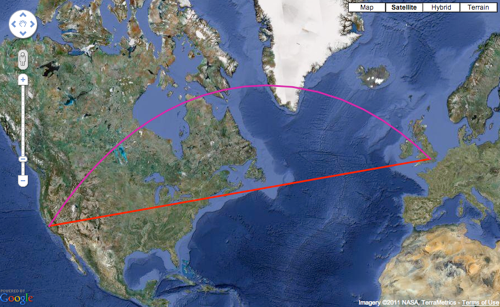
When represented on a projected map, the difference between the “flat” rhumb (red) and the spheric geometry based great circle lines (purple) are clear, but also misleading as the actual difference is less than a thousand kilometres between London and San Francisco and the rhumb line is actually longer !
So next time you take out the G-V you can at last accurately estimate fuel load (only joking !!)
It’s also of note that this new functionality is being delivered as an extension library which needs to be loaded in addition to the core v3 api, thereby making sure the core v3 api remains as small as possible for potential mobile use.
Share this post:


Google Research awards winter deadline 1st February
![]() Every year Google accepts research proposals for small grants awarded to researchers at academic institutions working on projects which in general terms improve access to information.
Every year Google accepts research proposals for small grants awarded to researchers at academic institutions working on projects which in general terms improve access to information.
Google funds Research Awards with very few restrictions and retains no intellectual property from the research itself, indeed there is an expectation that results from the research are open sourced and widely published.
Geospatial technology is one of the areas of research which receives funding and I am Google sponsor for a couple of funded projects,so if you are a researcher working in a University or Research Institution and are interested in applying for a grant, you have couple weeks to do so.
Visit this site, and submit your proposal by the 1st February.
Share this post:


Safe Software's FME 2011 Released
(I've been sick this week, thus the unusual low amount of stories published... will catch up in the coming days)
Last Tuesday Safe Software announced version 2011 of FME, their popular spatial data transformation platform software.
Several geoblogs offers reactions. Of note, there is:
- James Fee points to the official guide to what’s new
- Directions Mag's informative Q&A with Safe's vice-president of development and co-founder Dale Lutz
- Spatial Sustain offers a long discussion on the point clouds and LiDAR support in the new version: "The 2011 toolbox gives users the ability to reproject point clouds, changing between coordinate systems and vertical datums. There is the ability to reduce the point density of a dataset. You can split out and filter point clouds by flight line, source, classification or return. You can clip out specific polygons (regular or irregular). You can merge point clouds together. You can both tile and mosaic point clouds. You can create surface models, draping raster and vector data. You can also inspect attributes of the point cloud."
- If you're fond of numbers, Mapperz offers an FME 2011 story through numbers
File Geodatabase API - Released (Finally)
Map and GIS News finding blog. With so many Maps and GIS sites online now it is hard to find the good from the not so good. This blog tries to cut the cream and provide you with the newest, fastest, cleanest and most user friendly maps that are available online. News has location and it is mapped.
FME 2011 - Released
FME 2011 release today
'Probably the best Feature Manipulation Engine [FME] GIS/CAD conversion software you can get.'
FME 2011 release 'story through some numbers'
Top Pick...
Map and GIS News finding blog. With so many Maps and GIS sites online now it is hard to find the good from the not so good. This blog tries to cut the cream and provide you with the newest, fastest, cleanest and most user friendly maps that are available online. News has location and it is mapped.
ABC Community Queensland Flood Map
The ABC has launched an interactive map of the Queensland flood. Please 'Submit a Report' about what's happening in your area. The map includes both verified and...
Map and GIS News finding blog. With so many Maps and GIS sites online now it is hard to find the good from the not so good. This blog tries to cut the cream and provide you with the newest, fastest, cleanest and most user friendly maps that are available online. News has location and it is mapped.
